Posted on September 2nd, 2016
Last week I mentioned that tropical depression #8 would be impacting the coast and messing up our fishing for a few days, and then tropical depression #9 would follow in right behind and mess it up for a few days longer…..oh how I wish that were true now.
Tropical depression #8 didn’t mess our fishing up at all. The storm headed north east sooner than expected and didn’t get close enough to the coast to effect us one bit. Most boats experienced terrific conditions and had some really good fishing. We won’t be as lucky with tropical depression #9, which is now tropical storm Hermine.
Hermine is forecast to begin effecting Ocean City and surrounding areas by Saturday morning and the effects could be significant. Here is the inshore forecast from the National Weather Service.
Tonight
E wind 16 to 19 kt increasing to 20 to 23 kt after midnight. A chance of rain, mainly after 2am. Seas 4 ft building to 6 ft.
Saturday
Tropical storm conditions expected. E wind 30 to 40 kt, with gusts as high as 50 kt. A chance of rain and thunderstorms, then rain and possibly a thunderstorm after 8am. Some of the storms could produce heavy rainfall. Seas 9 ft building to 15 ft.
Saturday Night
Tropical storm conditions expected. NE wind 33 to 43 kt becoming N. Winds could gust as high as 55 kt. Showers likely. Seas around 19 ft.
Sunday
Tropical storm conditions expected. N wind 31 to 41 kt, with gusts as high as 50 kt. Showers likely. Seas around 17 ft.
Sunday Night
Tropical storm conditions possible. NNW wind 31 to 41 kt, with gusts as high as 50 kt. A chance of showers. Seas around 17 ft.
Labor Day
Tropical storm conditions possible. A chance of showers.
Monday Night
Tropical storm conditions possible.
Tuesday
Tropical storm conditions possible.
Tuesday Night
Tropical storm conditions possible.
As you can see, Ocean City will see the brunt of the storm Saturday, Saturday night and Sunday. The problem is that now Hermine is forecast to stall off of the coast of DelMarVa, possibly through Wednesday. This could lead to significant problems from wind, rain and flooding.
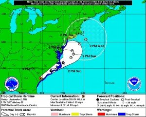
Strong winds and rain are one thing, but Ocean City and coastal areas could see the worst possible damage from flooding and storm surge. The problem that will occur with Hermine stalling off of our coast will come from the amount of water being pushed into the back bays from strong east and north east winds that would not able to flood out during tide changes because of the storm.
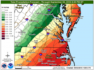
There is also a chance that Ocean City and surrounding areas could see as much as 4″ to 7″ of rain. Put that on top of what could be a tide surge 3′ to 6′ above normal and there could be serious issues.
Maryland Governor Larry Hogan today signed an Executive Order declaring a state of emergency in Caroline, Cecil, Dorchester, Kent, Queen Anne’s, Somerset, Talbot, Wicomico, Calvert, Charles, St. Mary’s and Worcester Counties beginning Friday, September 2 in anticipation of heavy rains, strong winds, and potential flooding associated with Tropical Storm Hermine. The Executive Order will allow the state to efficiently coordinate support and provide additional assistance to those counties. Ocean City is in Worcester County so is included in this state of emergency.
If you live in Ocean City or any coastal area that may be effected by Hermine you need to make preparations now. Stay tuned for more updates concerning Hermine on our Facebook page at www.facebook.com/fishinoc

